owned this note
owned this note
---
tags: Disfactory, 違章工廠, 違章工廠舉報系統
---
# 違章建築檢舉輔助系統 開發文件
<small>從 https://hackmd.io/ockOrC1VRfWyOwV8fvMF2w 搬來</small>
## 專案目的
https://github.com/yoyo930021/Disfactory
建立一個方便的舉報違章建築的系統
舉報完會自動轉換成實際舉報所需資料並產生公文
方便地球公民基金會做後續向政府舉報的動作
## 階段
1. ==now== 建立蒐集資料系統
2. 匯入已知的違章工廠資料
4. 提供給地球公民基金會使用的後臺
5. 背後轉換成公文
6. 串接 Bot 做到完全匿名
## 開發需求
- 前後端分離
- 前端 (1 位)
- Vue.js
- Vue Composition API
- [lib](https://github.com/vuejs/composition-api)
- [RFC](https://composition-api.vuejs.org/)
- OpenLayers
- 地圖顯示的套件
- 國土測繪圖資服務雲用同一套方便作業
- TypeScript
- 後端 (1-2 位)
- 程式語言
- Node.js
- Modern PHP
- Python
- 由最後負責後端的人討論決定
- 資料庫
- PostgreSQL
- 有內建強大的地理查詢能力
- SQLite
- 聽說跟 PostgreSQL 地理部分用同套 Lib
- MariaDB
- 單純比較熟悉
- 由最後負責後端的人討論決定
- 簡單爬蟲能力
- 可能需要分析國土測繪圖資服務雲的 API
## API
- 工廠資料
- 使用者上傳
- 國土舊有資料(ronny wang 農地和工廠經緯度:[full-info.csv](https://gist.github.com/ronnywang/f8bbf008e641b296c755f0167b51a550))
- x,y,xmin,ymin,xmax,ymax
- 可能的違章工廠座標(To be confirmed)
- ==1== GET `/factories?lng={lng}&lat={lat}&range={km}`
- 得到中心座標往外指定範圍的已有工廠資料
- response
```Typescript=
Array<{
id: number,
lng: number,
lat: number,
name: string,
type: Enum, // 工廠類型
images: [{
id: number,
url: string,
alt: string
}]
report_at?: number // 回報日期
status: Enum // 已回報 | 編輯中 | ... (TBD)
// post_process: string
}>
```
> 還缺公文回報內容(照片)
> 舊的違章工廠資料:地號中心點座標
> 新增違章工廠資料:使用者定位 GPS
> 需要確認一下國土規劃的 API 有提供到多少的地段地號轉座標與多邊形
> post_process 用 html or markdown
- ==2== PUT `/factories/{id}`
- 新增編輯指定 id 的工廠欄位資料
- request body
```json
{
attribute1: value1,
attribute2: value2,
}
```
> 要有編輯紀錄
- ==3== POST `/factories/{id}/images`
- 上傳指定 id 的工廠圖片
- content type: `multipart`
- request body:
```Typescript=
{
'image': 'image buffer here',
'data': { # provide this field will let
'path': 'https://i.imgur.com/123456.png', # the only field that cannot be null
'exif': {
'Latitude': 23.12,
'Longitude': 121.5566,
'DateTimeOriginal': '2020:03:21 12:33:59',
}
}
}
```
- response
```Typescript=
{ token: string }
```
- ==4== POST `/images`
- 上傳圖片
- content type: `multipart`
- request body:
```Typescript=
{
'image': 'image buffer here',
'data': { # provide this field will let
'path': 'https://i.imgur.com/123456.png', # the only field that cannot be null
'exif': {
'Latitude': 23.12,
'Longitude': 121.5566,
'DateTimeOriginal': '2020:03:21 12:33:59',
}
}
}
```
- response
```Typescript=
{ token: string }
```
- ==5== POST `/factories`
- 新增工廠
- request
```Typescript=
{
name: string,
type: Enum,
images: string[],
other: string,
lat: number,
lng: number,
nickname: string,
contact: string
}
```
> 少舉報人的聯絡方式(只有新增的時候會問):稱呼 & 聯絡方式(電話號碼或 email)
> other 是 description 的意思,上限 1024 cha
PS. 少了新增聯絡方式的流程 所以暫時沒設計相關 API
> 還有地球公民基金會後台的 API 還沒開
> 還需要編輯紀錄 log
目前資料是五萬筆
## 後端架構
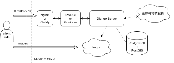
這是最基本要完成的部份。如果後續有時間再加:
- DB backup: 寫 cron job 或用個 master-slave (但不確定怎麼在 middle2 上設定)
- cron job 打 Imgur:因為半年沒 query 就會刪掉
- asynchronous task queue: 座標轉地號和圖片上傳都可以在背景做掉,減低 blocking time。不過會有 data inconsistency 的問題,處理起來有點複雜。
- DB caching: 由於不會很常增加新的違章工廠,加上總資料量其實很小,可以有寫個 write-through 機制的 cache
- Image backup and self-hosting
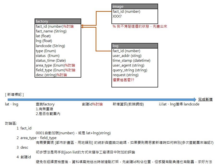
> type 是 fact_type
> fact_id 用 uuid
> 要不要新增的時候如果附近一公尺已有舉報工廠,會新增再已有工廠上=> 先開 issue
> img 要存 uuid 和 imgur 的 path
> img 要存上傳 created_time,最好存照片 EXIF 照相時間(沒有就 null)。上傳 imgur 時會把 EXIF 抹掉
> query_string: request body
> action_type
> action_body
>
## 其它連結
- Firebase 相關,可能可以拿來處裡 Geo 資料
- https://github.com/geofirestore/geofirestore-js
- https://angularfirebase.com/lessons/geolocation-query-in-firestore-realtime/
- https://firebase.google.com/docs/reference/android/com/google/firebase/firestore/GeoPoint
## API 研究
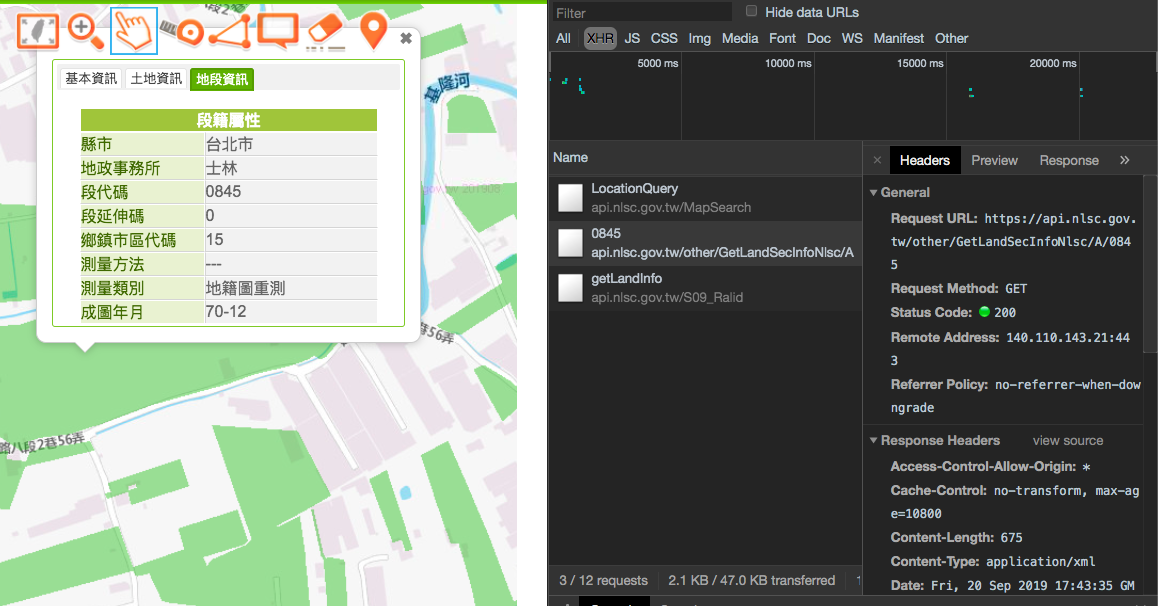
- https://maps.nlsc.gov.tw/
從經緯度拿地段
iTHome 鐵人賽 30天打造我的WebGIS https://ithelp.ithome.com.tw/users/20107816/ironman/1541
https://www.geoapify.com/leaflet-vs-openlayers/ Leaflet vs Openlayers
https://stackoverflow.com/questions/32046601/convert-xyz-coordinate-of-a-tile-to-longitude-latitude
[國土地段轉地號](https://maps.nlsc.gov.tw)
- https://github.com/ronnywang/luz.tcd.gov.tw : ronny 用 opencv 算外框對回去 geojson
- https://maps.nlsc.gov.tw/demo/105RGB%E8%89%B2%E7%A2%BC%E8%A1%A8.png 104 土地使用分類表
- https://docs.opencv.org/master/d3/dc0/group__imgproc__shape.html#gadf1ad6a0b82947fa1fe3c3d497f260e0
- opencv.js https://docs.opencv.org/3.4/d0/d84/tutorial_js_usage.html
- https://github.com/oliver-moran/jimp
- https://www.npmjs.com/package/replace-color
- [imgur API 研究](https://hackmd.io/snF73YIRT2KZ4Tw1oQWb2g)
- [運用 Django 上傳圖片的 API 教學](https://www.techiediaries.com/django-rest-image-file-upload-tutorial/)
- [DRF_function-based-views](https://www.django-rest-framework.org/api-guide/views/#function-based-views)
forEachLayerAtPixel


